Kairaki | |
|---|---|
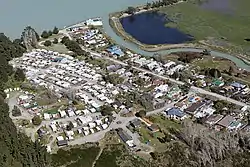 Kairaki on the north bank of the Waimakariri River | |
| Coordinates: 43°23′10″S 172°42′11″E / 43.386°S 172.703°E | |
| Country | New Zealand |
| Region | Canterbury |
| Territorial authority | Waimakariri District |
| Ward | Kaiapoi-Woodend Ward |
| Community | Kaiapoi-Tuahiwi Community |
| Electorates |
|
| Government | |
| • Territorial Authority | Waimakariri District Council |
| • Regional council | Environment Canterbury |
| • Mayor of Waimakariri | Dan Gordon |
| • Waimakariri MP | Matthew Doocey |
| • Te Tai Tonga MP | Tākuta Ferris |
| Area | |
| • Total | 0.88 km2 (0.34 sq mi) |
| Population (2018)[2] | |
| • Total | 129 |
| • Density | 150/km2 (380/sq mi) |
| Time zone | UTC+12 (NZST) |
| • Summer (DST) | UTC+13 (NZDT) |
| Postcode | 7630 |
| Area code | 03 |
Kairaki is a small rural community in the Waimakariri District, New Zealand.
The New Zealand Ministry for Culture and Heritage gives a translation of "sky eater" for Kairaki.[3]
Demographics
Kairaki covers 0.88 km2 (0.34 sq mi).[1] It is part of the larger Pegasus Bay statistical area.[4]
| Year | Pop. | ±% p.a. |
|---|---|---|
| 2006 | 225 | — |
| 2013 | 132 | −7.34% |
| 2018 | 129 | −0.46% |
| Source: [2] | ||
Kairaki had a population of 129 at the 2018 New Zealand census, a decrease of 3 people (−2.3%) since the 2013 census, and a decrease of 96 people (−42.7%) since the 2006 census. There were 66 households, comprising 72 males and 57 females, giving a sex ratio of 1.26 males per female. The median age was 60.0 years (compared with 37.4 years nationally), with 6 people (4.7%) aged under 15 years, 9 (7.0%) aged 15 to 29, 66 (51.2%) aged 30 to 64, and 51 (39.5%) aged 65 or older.
Ethnicities were 95.3% European/Pākehā, 7.0% Māori, 2.3% Pasifika, and 2.3% Asian. People may identify with more than one ethnicity.
Although some people chose not to answer the census's question about religious affiliation, 62.8% had no religion, 30.2% were Christian, and 2.3% were Muslim.
Of those at least 15 years old, 9 (7.3%) people had a bachelor's or higher degree, and 51 (41.5%) people had no formal qualifications. The median income was $22,600, compared with $31,800 nationally. 9 people (7.3%) earned over $70,000 compared to 17.2% nationally. The employment status of those at least 15 was that 48 (39.0%) people were employed full-time, 18 (14.6%) were part-time, and 3 (2.4%) were unemployed.[2]
Climate
The average temperature in summer is 16.2 °C, and in winter is 6.4 °C.[5]
| Month | Normal temperature |
|---|---|
| January | 16.7 °C |
| February | 16.3 °C |
| March | 15.0 °C |
| April | 12.1 °C |
| May | 8.8 °C |
| June | JUN |
| July | JUL |
| August | AUG |
| September | SEP |
| October | OCT |
| November | NOV |
| December | DEC |
References
- 1 2 "ArcGIS Web Application". statsnz.maps.arcgis.com. Retrieved 2 September 2021.
- 1 2 3 "Statistical area 1 dataset for 2018 Census". Statistics New Zealand. March 2020. 7024278.
- ↑ "1000 Māori place names". New Zealand Ministry for Culture and Heritage. 6 August 2019.
- ↑ 2018 Census place summary: Pegasus Bay
- ↑ "Weather statistics for NAME, Canterbury (New Zealand)". yr.no. Retrieved 29 November 2013.