Rayón | |
|---|---|
 | |
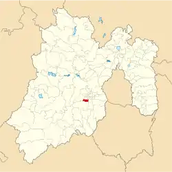 Location of the municipality in Mexico State | |
| Country | |
| State | Mexico (state) |
| Government | |
| • Municipal president | José Luis Robles Vázquez |
| Elevation | 2,570 m (8,430 ft) |
| Population (2005) | |
| • Total | 12,748 |
| Time zone | UTC-6 (Central Standard Time) |
| • Summer (DST) | UTC-5 (Central Daylight Time) |
Rayón is a municipality located in Toluca Region, the northeastern part of the state of Mexico in Mexico, the municipal seat is Santa María Rayón, formerly named Cuauhtenco. The municipality is located at a southern pass leading out of the Toluca Valley.[1]
Geography
The total municipality extends 84.37 km2 and borders with the municipalities of Tenango del Valle, Calimaya and Almoloya del Río.
Communication and transport
The Lerma-Tenango Highway, is a main highway that cross by Rayón, connect with Toluca to Tenango del Valle.
Politics
| Mayor | Time |
|---|---|
| Elias Arturo Sánchez Montes de Oca | 2009–2012 |
| Erick Vladimir Cedillo Hinojosa | 2012–2015 |
| José Luis Robles Vázquez | 2016– |
Economy
The economy is principally farming, cattle raising and small businesses, concentrating on the production of corn, beans and fruit.
Demography
Populated places in Rayón
| Town | Population |
| Total | 12 748 |
| Santa María Rayón |
Culture
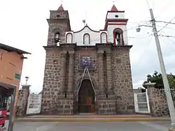
Guadalupe Church in Rayón.
Monuments
- Saint Mary of Guadalupe Parish is a monument in Rayón town.
References
- ↑ "Rayón". Enciclopedia de los Municipios de México. Instituto Nacional para el Federalismo y el Desarrollo Municipal. Archived from the original on August 19, 2016. Retrieved June 6, 2009.

This article is issued from Wikipedia. The text is licensed under Creative Commons - Attribution - Sharealike. Additional terms may apply for the media files.