Center Township | |
|---|---|
 | |
| Coordinates: 39°40′57″N 094°51′41″W / 39.68250°N 94.86139°W | |
| Country | United States |
| State | Missouri |
| County | Buchanan |
| Area | |
| • Total | 36.32 sq mi (94.08 km2) |
| • Land | 36.32 sq mi (94.08 km2) |
| • Water | 0 sq mi (0 km2) 0% |
| Elevation | 912 ft (278 m) |
| Population (2010) | |
| • Total | 3,049 |
| • Density | 81.9/sq mi (31.6/km2) |
| FIPS code | 29-12484[2] |
| GNIS feature ID | 0766338 |
Center Township is one of twelve townships in Buchanan County, Missouri, USA. As of the 2010 census, its population was 3,049.[3]
Center Township was established in 1841, and named for its location near the geographical center of Buchanan County.[4]
Geography
Center Township covers an area of 36.32 square miles (94.1 km2) and contains no incorporated settlements. It contains five cemeteries: Feuquay, New King Hill, Old Sparta, Parker and Pleasant Ridge.
References
- ↑ "US Board on Geographic Names". United States Geological Survey. October 25, 2007. Retrieved January 31, 2008.
- ↑ "U.S. Census website". United States Census Bureau. Retrieved January 31, 2008.
- ↑ U.S. Census Bureau (September 2012). "2010 Census of Population and Housing, Population and Housing Unit Counts, Missouri" (PDF). U.S. Government Printing Office. Archived from the original (PDF) on October 21, 2016.
- ↑ "Buchanan County Place Names, 1928–1945 (archived)". The State Historical Society of Missouri. Archived from the original on June 24, 2016. Retrieved September 4, 2016.
{{cite web}}: CS1 maint: bot: original URL status unknown (link)
External links
Municipalities and communities of Buchanan County, Missouri, United States | ||
|---|---|---|
| Cities | 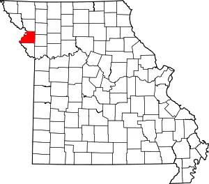 Map of Missouri highlighting Buchanan County | |
| Villages | ||
| Townships | ||
| CDP | ||
| Other communities | ||
| Footnotes | ‡This populated place also has portions in an adjacent county or counties | |
This article is issued from Wikipedia. The text is licensed under Creative Commons - Attribution - Sharealike. Additional terms may apply for the media files.