Douglas County | |
|---|---|
 Douglas County Courthouse and veterans' memorial | |
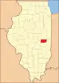
 Location within the U.S. state of Illinois | |
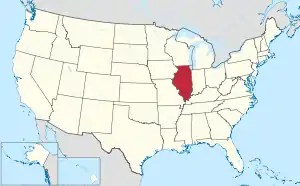 Illinois's location within the U.S. | |
| Coordinates: 39°46′N 88°13′W / 39.77°N 88.22°W | |
| Country | |
| State | |
| Founded | 1859 |
| Named for | Stephen A. Douglas |
| Seat | Tuscola |
| Largest city | Tuscola |
| Area | |
| • Total | 417 sq mi (1,080 km2) |
| • Land | 416 sq mi (1,080 km2) |
| • Water | 0.6 sq mi (2 km2) 0.1% |
| Population (2020) | |
| • Total | 19,740 |
| • Estimate (2021)[1] | 19,722 |
| • Density | 47/sq mi (18/km2) |
| Time zone | UTC−6 (Central) |
| • Summer (DST) | UTC−5 (CDT) |
| Congressional district | 15th |
| Website | www |
Douglas County is a county located in the U.S. state of Illinois. As of the 2020 United States Census, the population was 19,740.[2] The county seat is Tuscola.[3]
History
Douglas County was formed in 1859 out of Coles County. It was named for Stephen A. Douglas,[4] who was elected to the United States Senate in 1858, following the Lincoln–Douglas debates.
 The creation of Douglas and Ford Counties in 1859 resulted in Illinois' current county map.
Geography

According to the US Census Bureau, the county has a total area of 417 square miles (1,080 km2), of which 417 square miles (1,080 km2) is land and 0.6 square miles (1.6 km2) (0.1%) is water.[5]
Climate and weather
| Tuscola, Illinois | ||||||||||||||||||||||||||||||||||||||||||||||||||||||||||||
|---|---|---|---|---|---|---|---|---|---|---|---|---|---|---|---|---|---|---|---|---|---|---|---|---|---|---|---|---|---|---|---|---|---|---|---|---|---|---|---|---|---|---|---|---|---|---|---|---|---|---|---|---|---|---|---|---|---|---|---|---|
| Climate chart (explanation) | ||||||||||||||||||||||||||||||||||||||||||||||||||||||||||||
| ||||||||||||||||||||||||||||||||||||||||||||||||||||||||||||
| ||||||||||||||||||||||||||||||||||||||||||||||||||||||||||||
In recent years, average temperatures in the county seat of Tuscola have ranged from a low of 18 °F (−8 °C) in January to a high of 88 °F (31 °C) in July, although a record low of −26 °F (−32 °C) was recorded in December 1989 and a record high of 113 °F (45 °C) was recorded in July 1954. Average monthly precipitation ranged from 2.12 inches (54 mm) in February to 4.64 inches (118 mm) in July.[6]
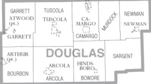
Adjacent counties
- Champaign County - north
- Vermilion County - northeast
- Edgar County - east
- Coles County - south
- Moultrie County - west
- Piatt County - northwest
Major highways
Demographics
| Census | Pop. | Note | %± |
|---|---|---|---|
| 1860 | 7,140 | — | |
| 1870 | 13,484 | 88.9% | |
| 1880 | 15,853 | 17.6% | |
| 1890 | 17,669 | 11.5% | |
| 1900 | 19,097 | 8.1% | |
| 1910 | 19,591 | 2.6% | |
| 1920 | 19,604 | 0.1% | |
| 1930 | 17,914 | −8.6% | |
| 1940 | 17,590 | −1.8% | |
| 1950 | 16,706 | −5.0% | |
| 1960 | 19,243 | 15.2% | |
| 1970 | 18,997 | −1.3% | |
| 1980 | 19,774 | 4.1% | |
| 1990 | 19,464 | −1.6% | |
| 2000 | 19,922 | 2.4% | |
| 2010 | 19,980 | 0.3% | |
| 2020 | 19,740 | −1.2% | |
| 2021 (est.) | 19,722 | −0.1% | |
| US Decennial Census[7] 1790-1960[8] 1900-1990[9] 1990-2000[10] 2010-2014[11] 2020[2] | |||

As of the 2010 United States Census, there were 19,980 people, 7,720 households, and 5,377 families living in the county.[12] The population density was 48.0 inhabitants per square mile (18.5/km2). There were 8,390 housing units at an average density of 20.1 per square mile (7.8/km2).[5] The racial makeup of the county was 95.7% white, 0.4% Asian, 0.3% black or African American, 0.2% American Indian, 2.3% from other races, and 1.2% from two or more races. Those of Hispanic or Latino origin made up 6.1% of the population.[12] In terms of ancestry, 29.6% were German, 12.6% were American, 12.1% were English, and 10.7% were Irish.[13]
Of the 7,720 households, 32.6% had children under the age of 18 living with them, 57.0% were married couples living together, 8.5% had a female householder with no husband present, 30.3% were non-families, and 26.1% of all households were made up of individuals. The average household size was 2.57 and the average family size was 3.11. The median age was 38.7 years.[12]
The median income for a household in the county was $46,941 and the median income for a family was $60,352. Males had a median income of $41,318 versus $28,731 for females. The per capita income for the county was $21,438. About 7.1% of families and 10.2% of the population were below the poverty line, including 14.0% of those under age 18 and 7.2% of those age 65 or over.[14]
Communities
Cities
- Arcola
- Newman
- Tuscola (seat)
- Villa Grove
Villages
Unincorporated communities
Townships
Politics
Douglas is a strongly Republican county. Apart from a narrow plurality of thirty-two votes to Bill Clinton in 1992, it has voted Republican in every Presidential election since 1968, and in all but five overall since 1880. Despite its long-time Republican leanings, Hillary Clinton's 2016 performance of gaining a mere 23.8 percent of the county's vote stands over six percent worse than any Democrat since the Civil War.
| Year | Republican | Democratic | Third party | |||
|---|---|---|---|---|---|---|
| No. | % | No. | % | No. | % | |
| 2020 | 6,227 | 71.08% | 2,335 | 26.66% | 198 | 2.26% |
| 2016 | 5,698 | 69.53% | 1,949 | 23.78% | 548 | 6.69% |
| 2012 | 5,334 | 67.34% | 2,430 | 30.68% | 157 | 1.98% |
| 2008 | 5,005 | 59.73% | 3,228 | 38.52% | 146 | 1.74% |
| 2004 | 5,702 | 66.77% | 2,767 | 32.40% | 71 | 0.83% |
| 2000 | 4,734 | 58.07% | 3,215 | 39.44% | 203 | 2.49% |
| 1996 | 3,272 | 46.66% | 2,955 | 42.14% | 786 | 11.21% |
| 1992 | 3,309 | 39.98% | 3,341 | 40.37% | 1,626 | 19.65% |
| 1988 | 4,378 | 57.62% | 3,184 | 41.91% | 36 | 0.47% |
| 1984 | 5,691 | 66.14% | 2,886 | 33.54% | 27 | 0.31% |
| 1980 | 5,330 | 64.26% | 2,564 | 30.91% | 400 | 4.82% |
| 1976 | 4,635 | 54.39% | 3,826 | 44.90% | 61 | 0.72% |
| 1972 | 5,840 | 68.66% | 2,656 | 31.23% | 10 | 0.12% |
| 1968 | 5,058 | 59.25% | 2,824 | 33.08% | 655 | 7.67% |
| 1964 | 4,223 | 47.35% | 4,695 | 52.65% | 0 | 0.00% |
| 1960 | 5,761 | 61.95% | 3,532 | 37.98% | 6 | 0.06% |
| 1956 | 5,559 | 66.66% | 2,774 | 33.27% | 6 | 0.07% |
| 1952 | 5,530 | 67.10% | 2,706 | 32.84% | 5 | 0.06% |
| 1948 | 4,181 | 58.65% | 2,893 | 40.58% | 55 | 0.77% |
| 1944 | 4,684 | 58.29% | 3,323 | 41.36% | 28 | 0.35% |
| 1940 | 5,451 | 54.34% | 4,513 | 44.99% | 67 | 0.67% |
| 1936 | 4,606 | 47.51% | 5,029 | 51.88% | 59 | 0.61% |
| 1932 | 3,108 | 37.74% | 4,954 | 60.15% | 174 | 2.11% |
| 1928 | 4,890 | 68.19% | 2,239 | 31.22% | 42 | 0.59% |
| 1924 | 4,046 | 55.65% | 2,315 | 31.84% | 909 | 12.50% |
| 1920 | 4,885 | 65.21% | 2,308 | 30.81% | 298 | 3.98% |
| 1916 | 4,564 | 52.17% | 3,768 | 43.07% | 416 | 4.76% |
| 1912 | 1,386 | 31.03% | 1,633 | 36.56% | 1,448 | 32.42% |
| 1908 | 2,656 | 55.33% | 1,917 | 39.94% | 227 | 4.73% |
| 1904 | 2,518 | 54.80% | 1,685 | 36.67% | 392 | 8.53% |
| 1900 | 2,733 | 55.46% | 2,106 | 42.74% | 89 | 1.81% |
| 1896 | 2,666 | 54.78% | 2,140 | 43.97% | 61 | 1.25% |
| 1892 | 2,246 | 50.48% | 1,999 | 44.93% | 204 | 4.59% |
See also
References
- ↑ "QuickFacts: Douglas County, Illinois". Census.gov. Retrieved May 24, 2022.
- 1 2 2020 Population and Housing State Data | Illinois
- ↑ "Find a County". National Association of Counties. Archived from the original on May 31, 2011. Retrieved June 7, 2011.
- ↑ Gannett, Henry (1905). The Origin of Certain Place Names in the United States. Govt. Print. Off. p. 108.
- 1 2 "Population, Housing Units, Area, and Density: 2010 - County". US Census Bureau. Archived from the original on February 12, 2020. Retrieved July 11, 2015.
- 1 2 "Monthly Averages for Tuscola IL". The Weather Channel. Retrieved January 27, 2011.
- ↑ "US Decennial Census". US Census Bureau. Retrieved July 4, 2014.
- ↑ "Historical Census Browser". University of Virginia Library. Retrieved July 4, 2014.
- ↑ "Population of Counties by Decennial Census: 1900 to 1990". US Census Bureau. Retrieved July 4, 2014.
- ↑ "Census 2000 PHC-T-4. Ranking Tables for Counties: 1990 and 2000" (PDF). US Census Bureau. Archived (PDF) from the original on March 27, 2010. Retrieved July 4, 2014.
- ↑ "State & County QuickFacts". US Census Bureau. Archived from the original on June 6, 2011. Retrieved July 4, 2014.
- 1 2 3 "Profile of General Population and Housing Characteristics: 2010 Demographic Profile Data". US Census Bureau. Archived from the original on February 13, 2020. Retrieved July 11, 2015.
- ↑ "Selected Social Characteristics in the United States – 2006-2010 American Community Survey 5-Year Estimates". US Census Bureau. Archived from the original on February 13, 2020. Retrieved July 11, 2015.
- ↑ "Selected Economic Characteristics – 2006-2010 American Community Survey 5-Year Estimates". US Census Bureau. Archived from the original on February 13, 2020. Retrieved July 11, 2015.
- ↑ Leip, David. "Atlas of US Presidential Elections". uselectionatlas.org. Retrieved November 1, 2018.
External links
Places adjacent to Douglas County, Illinois | ||||||||||||||||
|---|---|---|---|---|---|---|---|---|---|---|---|---|---|---|---|---|
| ||||||||||||||||
Municipalities and communities of Douglas County, Illinois, United States | ||
|---|---|---|
| Cities | Map of Illinois highlighting Douglas County | |
| Villages | ||
| Townships | ||
| Unincorporated communities | ||
| Ghost town | ||
| Footnotes | ‡This populated place also has portions in an adjacent county or counties | |