Grainville-Langannerie | |
|---|---|
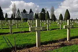 The Polish cemetery in Grainville-Langannerie | |
Location of Grainville-Langannerie | |
 Grainville-Langannerie  Grainville-Langannerie | |
| Coordinates: 49°00′45″N 0°16′18″W / 49.0125°N 0.2717°W | |
| Country | France |
| Region | Normandy |
| Department | Calvados |
| Arrondissement | Caen |
| Canton | Le Hom |
| Intercommunality | Cingal-Suisse Normande |
| Government | |
| • Mayor (2020–2026) | Sandrine Romagné[1] |
| Area 1 | 5.32 km2 (2.05 sq mi) |
| Population | 759 |
| • Density | 140/km2 (370/sq mi) |
| Time zone | UTC+01:00 (CET) |
| • Summer (DST) | UTC+02:00 (CEST) |
| INSEE/Postal code | 14310 /14190 |
| Elevation | 101–175 m (331–574 ft) (avg. 120 m or 390 ft) |
| 1 French Land Register data, which excludes lakes, ponds, glaciers > 1 km2 (0.386 sq mi or 247 acres) and river estuaries. | |
Grainville-Langannerie (French pronunciation: [ɡʁɛ̃vil lɑ̃ɡanʁi] ⓘ) is a commune in the Calvados department in the Normandy region in northwestern France.
Population
| Year | Pop. | ±% |
|---|---|---|
| 1962 | 466 | — |
| 1968 | 531 | +13.9% |
| 1975 | 539 | +1.5% |
| 1982 | 498 | −7.6% |
| 1990 | 466 | −6.4% |
| 1999 | 522 | +12.0% |
| 2008 | 650 | +24.5% |
Sights
The town contains a cemetery of Polish soldiers killed in the Battle of Hill 262 during World War II.
See also
References
- ↑ "Répertoire national des élus: les maires". data.gouv.fr, Plateforme ouverte des données publiques françaises (in French). 9 August 2021.
- ↑ "Populations légales 2021". The National Institute of Statistics and Economic Studies. 28 December 2023.
Wikimedia Commons has media related to Grainville-Langannerie.
This article is issued from Wikipedia. The text is licensed under Creative Commons - Attribution - Sharealike. Additional terms may apply for the media files.