Großstübing | |
|---|---|
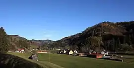 Großstübing | |
 Coat of arms | |
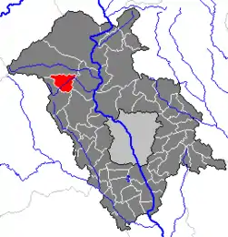 Location within Graz-Umgebung district | |
 Großstübing Location within Austria | |
| Coordinates: 47°11′33″N 15°14′05″E / 47.19250°N 15.23472°E | |
| Country | Austria |
| State | Styria |
| District | Graz-Umgebung |
| Government | |
| • Mayor | Dir. Franz Stampler |
| Area | |
| • Total | 17.77 km2 (6.86 sq mi) |
| Elevation | 543 m (1,781 ft) |
| Population (1 January 2016)[1] | |
| • Total | 351 |
| • Density | 20/km2 (51/sq mi) |
| Time zone | UTC+1 (CET) |
| • Summer (DST) | UTC+2 (CEST) |
| Postal code | 8114, 8124 |
| Area code | 03125 |
| Vehicle registration | GU |
| Website | www.grossstuebing. steiermark.at |
Großstübing is a former municipality in the district of Graz-Umgebung in the Austrian state of Styria. Since the 2015 Styria municipal structural reform, it is part of the municipality Deutschfeistritz.[2]
Population
| Year | Pop. | ±% |
|---|---|---|
| 1869 | 664 | — |
| 1880 | 675 | +1.7% |
| 1890 | 681 | +0.9% |
| 1900 | 601 | −11.7% |
| 1910 | 595 | −1.0% |
| 1923 | 658 | +10.6% |
| 1934 | 597 | −9.3% |
| 1939 | 532 | −10.9% |
| 1951 | 519 | −2.4% |
| 1961 | 432 | −16.8% |
| 1971 | 407 | −5.8% |
| 1981 | 374 | −8.1% |
| 1991 | 377 | +0.8% |
| 2001 | 372 | −1.3% |
References
This article is issued from Wikipedia. The text is licensed under Creative Commons - Attribution - Sharealike. Additional terms may apply for the media files.