Kings Prairie Township | |
|---|---|
 | |
| Coordinates: 36°52′46″N 093°52′32″W / 36.87944°N 93.87556°W | |
| Country | United States |
| State | Missouri |
| County | Barry |
| Area | |
| • Total | 28.74 sq mi (74.43 km2) |
| • Land | 28.73 sq mi (74.41 km2) |
| • Water | 0.01 sq mi (0.02 km2) 0.03% |
| Elevation | 1,440 ft (439 m) |
| Population (2000) | |
| • Total | 968 |
| • Density | 33.7/sq mi (13/km2) |
| FIPS code | 29-38837[2] |
| GNIS feature ID | 0766257 |
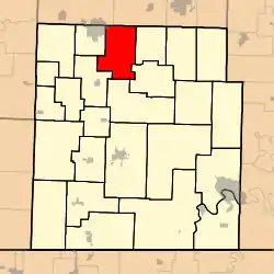
Kings Prairie Township is one of twenty-five townships in Barry County, Missouri, United States. As of the 2000 census, its population was 968.
The namesake Kings Prairie was named after George W. King, a pioneer settler.[3]
Geography
Kings Prairie Township covers an area of 28.74 square miles (74.4 km2) and contains no incorporated settlements. It contains two cemeteries: Goodnight and Henderson.
References
- ↑ "US Board on Geographic Names". United States Geological Survey. October 25, 2007. Retrieved January 31, 2008.
- ↑ "U.S. Census website". United States Census Bureau. Retrieved January 31, 2008.
- ↑ "Barry County Place Names, 1928-1945 (archived)". The State Historical Society of Missouri. Archived from the original on June 24, 2016. Retrieved August 30, 2016.
{{cite web}}: CS1 maint: bot: original URL status unknown (link)
External links
Municipalities and communities of Barry County, Missouri, United States | ||
|---|---|---|
| Cities |  Map of Missouri highlighting Barry County | |
| Villages | ||
| Townships | ||
| CDPs | ||
| Unincorporated communities | ||
| Ghost towns | ||
| Footnotes | ‡This populated place also has portions in an adjacent county or counties | |
This article is issued from Wikipedia. The text is licensed under Creative Commons - Attribution - Sharealike. Additional terms may apply for the media files.