Mala Loka | |
|---|---|
 | |
 Mala Loka Location in Slovenia | |
| Coordinates: 46°6′32.46″N 14°34′34.04″E / 46.1090167°N 14.5761222°E | |
| Country | |
| Traditional region | Upper Carniola |
| Statistical region | Central Slovenia |
| Municipality | Domžale |
| Area | |
| • Total | 0.36 km2 (0.14 sq mi) |
| Elevation | 283 m (928 ft) |
| Population (2020) | |
| • Total | 199 |
| • Density | 550/km2 (1,400/sq mi) |
| [1] | |
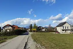
Mala Loka (pronounced [ˈmaːla ˈloːka]; German: Kleinlack[2]) is a small settlement on the left bank of the Kamnik Bistrica River south of Domžale in the Upper Carniola region of Slovenia.[3]
References
- ↑ Statistical Office of the Republic of Slovenia
- ↑ Leksikon občin kraljestev in dežel zastopanih v državnem zboru, vol. 6: Kranjsko. 1906. Vienna: C. Kr. Dvorna in Državna Tiskarna, p. 18.
- ↑ Domžale municipal site
External links
 Media related to Mala Loka at Wikimedia Commons
- Mala Loka on Geopedia
| Settlements | Administrative seat: Domžale
|  |
|---|---|---|
| Infrastructure | ||
| Landmarks |
| |
| Notable people | ||
This article is issued from Wikipedia. The text is licensed under Creative Commons - Attribution - Sharealike. Additional terms may apply for the media files.