Saint-Colomb-de-Lauzun | |
|---|---|
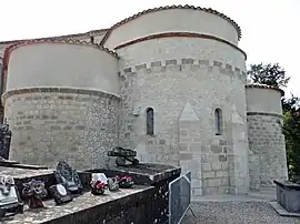 The church in Saint-Colomb-de-Lauzun | |
Location of Saint-Colomb-de-Lauzun | |
 Saint-Colomb-de-Lauzun  Saint-Colomb-de-Lauzun | |
| Coordinates: 44°36′54″N 0°28′28″E / 44.615°N 0.4744°E | |
| Country | France |
| Region | Nouvelle-Aquitaine |
| Department | Lot-et-Garonne |
| Arrondissement | Marmande |
| Canton | Le Val du Dropt |
| Intercommunality | Pays de Lauzun |
| Government | |
| • Mayor (2020–2026) | Nicolas Gris[1] |
| Area 1 | 23.19 km2 (8.95 sq mi) |
| Population | 473 |
| • Density | 20/km2 (53/sq mi) |
| Time zone | UTC+01:00 (CET) |
| • Summer (DST) | UTC+02:00 (CEST) |
| INSEE/Postal code | 47235 /47410 |
| Elevation | 67–136 m (220–446 ft) (avg. 80 m or 260 ft) |
| 1 French Land Register data, which excludes lakes, ponds, glaciers > 1 km2 (0.386 sq mi or 247 acres) and river estuaries. | |
Saint-Colomb-de-Lauzun (French pronunciation: [sɛ̃ kɔlɔ̃ də lozœ̃], literally Saint-Colomb of Lauzun; Occitan: Sent Colomb de Lausun) is a commune in the Lot-et-Garonne department in south-western France.[3]
See also
References
- ↑ "Répertoire national des élus: les maires" (in French). data.gouv.fr, Plateforme ouverte des données publiques françaises. 13 September 2022.
- ↑ "Populations légales 2021". The National Institute of Statistics and Economic Studies. 28 December 2023.
- ↑ INSEE commune file
Wikimedia Commons has media related to Saint-Colomb-de-Lauzun.
This article is issued from Wikipedia. The text is licensed under Creative Commons - Attribution - Sharealike. Additional terms may apply for the media files.