| The Helmet | |
|---|---|
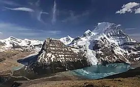 Mt. Robson (far right), The Helmet (right) | |
| Highest point | |
| Elevation | 3,420 m (11,220 ft)[1] |
| Prominence | 128 m (420 ft)[2] |
| Parent peak | Mount Robson (3954 m) |
| Listing | Mountains of British Columbia |
| Coordinates | 53°06′54″N 119°08′30″W / 53.115°N 119.141666°W[3] |
| Geography | |
 The Helmet  The Helmet | |
| Country | Canada |
| Province | British Columbia |
| District | Cariboo Land District[4] |
| Protected area | Mount Robson Provincial Park |
| Parent range | Rainbow Range Canadian Rockies |
| Topo map | NTS 83E3 Mount Robson[3] |
| Climbing | |
| First ascent | 1928 by G. Engelhard and H. Fuhrer[2] |
The Helmet is a subsidiary peak on the Mount Robson massif located within Mount Robson Provincial Park in British Columbia, Canada. It is part of the Rainbow Range which is a sub-range of the Canadian Rockies.
See also
References
- ↑ "Topographic map of The Helmet". opentopomap.org. Retrieved 2023-08-18.
- 1 2 "The Helmet". Bivouac.com. Retrieved 2023-08-19.
- 1 2 "The Helmet". Geographical Names Data Base. Natural Resources Canada. Retrieved 2023-08-19.
- ↑ "The Helmet". BC Geographical Names. Retrieved 2023-08-19.
External links
- Mount Robson Provincial Park website—BC Parks
- The Helmet weather: Mountain Forecast
This article is issued from Wikipedia. The text is licensed under Creative Commons - Attribution - Sharealike. Additional terms may apply for the media files.